Map of Epsom Downs station, London
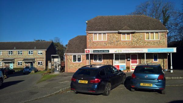
Epsom Downs station
| Postcode | KT17 4JX |
|---|
Transport
| Travel zone | 6 |
|---|---|
| Tube/Rail lines | |
| Next stations | |
| Nearby stations | |
| Bus stops |
Epsom Golf Club (N)
Bunbury Way (S)
Bunbury Way (N)
Montrouge Crescent (NE)
Epsom College (S)
Montrouge Crescent (SW)
|
| Station code (TLC) | EPD |
| Station code (NLC) | 5361 |
| Owner | Govia Thameslink Railway (Southern) |
| National Rail Enquiries | |
Live Departures
Live Arrivals
Usage
Entries and exits
Interchanges
| Year | Entries and exits | Annual change % | Interchanges | Annual change % |
|---|---|---|---|---|
| 2023 | 105,684 | 55.5 % | ||
| 2022 | 67,982 | 132.4 % | ||
| 2021 | 29,250 | -73.9 % | ||
| 2020 | 112,090 | 1.6 % | ||
| 2019 | 110,374 | 25.5 % | ||
| 2018 | 87,940 | -3.2 % | ||
| 2017 | 90,840 | -18.9 % | ||
| 2016 | 111,946 | 25.7 % | ||
| 2015 | 89,074 | 2.4 % | ||
| 2014 | 86,994 | 4.3 % | ||
| 2013 | 83,370 | 4.9 % | ||
| 2012 | 79,452 | 14.0 % | ||
| 2011 | 69,672 | 2.6 % | ||
| 2010 | 67,916 | -3.9 % | ||
| 2009 | 70,654 | 1.2 % | ||
| 2008 | 69,800 | 28.9 % | ||
| 2007 | 54,153 | 8.5 % | ||
| 2006 | 49,901 | 12.5 % | ||
| 2005 | 44,338 |
Note: Data is for financial years, so 2020 is April 2019 to March 2020
Geography
| Latitude | 51.323686 | |
|---|---|---|
| Longitude | -0.238955 | |
| Easting | 522805 | |
| Northing | 159756 | |
| Grid reference | TQ228597 | |
| UTM reference | 30U 692374 5689440 | |
| what3words | ||
| Plus code | ||
| Distance away |
Postcodes
This map shows the postcodes where this station is the nearest to the postcode (as the crow flies)