Since I've had quite a few requests for it, I've updated the postcode data on the website to include the Index of Multiple Deprivation (IMD) 2025 dataset for England.
Posts tagged 'Postcodes'
Blog main pageThursday, April 23, 2026
Sunday, March 22, 2026
Apologies for the late update, something is happening with the ONS website that meant I couldn't find the latest release using my usual search. I did eventually find it when looking for something else.
https://www.doogal.co.uk/UKPostcodes
People have asked about the latest Index of Multiple Deprivation (IMD) statistics. These haven't been updated in this release. I will now investigate including this data from the original sources.
If you spot any problems, let me know
Sunday, November 30, 2025
The latest postcode data from the ONS is now available on the site. Everything looks in order but let me know if you find anything amiss
Wednesday, September 3, 2025
I've updated the postcode data on the site with the latest ONS data. There are problems with the locations of 15 new Northern Irish postcodes, which I've removed for the moment. This is something of an improvement from the last release which initially misplaced all Northern Irish postcodes. If you spot any other problems, let me know
Friday, June 20, 2025
I'm a little late with this (not entirely my fault) but I have uploaded the latest data from the ONS to the website. It all seems in order but let me know if you spot any problems
Friday, February 28, 2025
I've uploaded the latest ONS postcode date to the site. It all looks OK but let me know if you spot anything amiss
Saturday, January 11, 2025
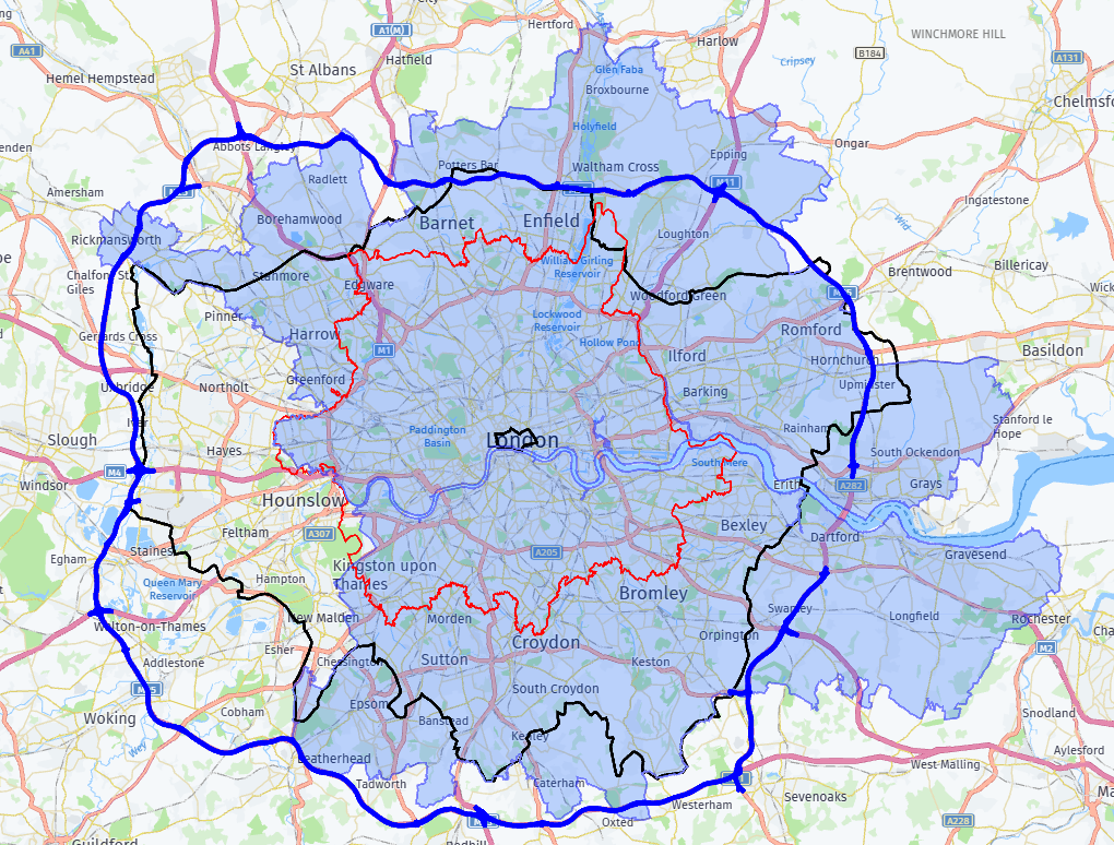
One of the more popular pages on the site is the postcodes in the City of London administrative area. This confused me for a while since the City of London is a small area that is important for financial services but not much else. I came to the conclusion that it was based on people trying to find a list of all London postcodes so I added a link to a more comprehensive page of London postcodes. But then I wondered if that was really what people would want from a list of London postcodes and where in fact London ends. So here's a brief description of what the options are.
The City of London administrative area does closely line up with what was considered London several hundred years ago. It's now more commonly known as the Square Mile and as you'd guess from the name, it's tiny. It's the smallest black area in the map above
This list of London postcodes is a list of postcodes that are considered to be in the London post town and consists of the E, EC, N, NW, SE, SW, W and WC postcode areas. I guess when those postcode areas were created, that may have been considered the extent of London, but I don't think anyone would think that now, Wembley Stadium and Heathrow Airport are both outside it. It's the red area in the map.
The larger black area above is the area covered by the Greater London Authority, which is probably what most people would consider as London these days. You can download data for this area here
But even that may not be enough. Maybe you think anything inside the M25 is London. Certainly London's urban sprawl now extends beyond the boundary of the GLA. I don't currently have data for this but it's on my To Do list. It's the blue area above.
But the urban sprawl extends beyond the M25 in places, so maybe that doesn't really define the boundary. What about the area where people mostly work in London? The London Travel to Work Area data is here and is shown above as the blue shaded area. That gives a completely different area than the others, with a big chunk taken out of the Western side by areas where people work in Slough and Heathrow, rather than London.
So to answer the original question, where does London end? It's not really clear. Sorry I've not been more helpful, but maybe it will help you decide which specific London data you should download
Saturday, December 21, 2024
A little late but I've just uploaded the latest postcode data to the site. The biggest change is that new built up areas (from 2024) are included in the data.
I've run my usual sanity checks and not found any issues, but let me know if you find anything amiss
Sunday, September 22, 2024
I've started to include road names in the UK postcode CSV downloads. Let me know if you spot any problems or if you want them included in any other downloads
Sunday, September 8, 2024
I've uploaded the latest ONS postcode data to the site. There have been some changes to the data provided. Built up areas have been updated to the latest 2022 areas and built up area sub-divisions no longer exist. Constituency boundaries are now from the 2024 election. This means the layout of the CSV files has changed and there will be more changes as I clean up any other references to the old data.
As usual, let me know if you see any problems
Wednesday, August 14, 2024
I've updated the Multiple Postcodes page so you can now use it to get a list of all the streets that are covered by the selected postcode areas. You can grab the data as CSV or KML. Any suggestions or problems, let me know
Saturday, May 25, 2024
I've uploaded the latest ONS postcode data to the site. I've run my usual sanity checks and everything appears OK but let me know if you spot anything weird.
To celebrate the upcoming election and because I've had a few requests for them, I've added data for new constituencies to the site. The pages are a little sparse at the moment but if all you require is CSV data for a constituency, you should be good to go.
Tuesday, April 23, 2024
I got a question the other day about the electoral constituency data, specifically if I had the data for the new constituencies that will come into existence at the next General Election. The data on the site is from the ONS Postcode directory which is for the current constituencies. It seems the ONS update this kind of boundary data when it becomes active, i.e after an election, so I can't currently provide it from that source. But the ONS have recently released the data separately. If the postcode data for one of these new constituencies would be useful to you, let me know and I can produce a list of the postcodes for you. I'm unlikely to do it for all constituencies unless there's a big demand
Sunday, March 3, 2024
I've imported the latest postcode data from the ONS to the website. I had some issues with parishes, the postcodes reference new parish codes but the parish name lookups still use the old codes, so I've had to manually fix up the data, which I may well have messed up. If you notice any issues with parishes or anywhere else in the postcode data, let me know
Saturday, January 20, 2024
I've updated the site to include details of another level of administrative area, county electoral divisions. For example - Cambridgeshire postcodes
You can grab the data as CSV, KML, GeoJSON and Shape files. Let me know if you hit any problems.
In unrelated news, I've adjusted the blog subscription so you can subscribe just for blog posts about website updates or for all updates, since I occasionally rant about random subjects that most subscribers probably aren't interested in. If you've signed up already, you will only receive notifications about website updates. If you want to sign up for everything, currently you'll need to unsubscribe and sign up again. If you haven't signed up and would like to, head over to the sign-up page
Saturday, December 2, 2023
I've uploaded the latest ONS postcode data. There is an issue with ITL codes in the Northamptonshire area which I can't currently resolve but I will keep an eye out for updated data from the ONS. If you see any other problems, let me know
Wednesday, November 1, 2023
I was complaining recently about the poor state of UPRN data. But it turns out I was mostly wrong and the problem was my poor research abilities (or things have changed for the better recently). A Disqus conversation led me to this page which provides the links between different identifiers.
These are all CSV files that can be imported into your favourite database. To get the street name of a UPRN, we need to download the UPRN -> USRN links file. Once we've got the USRN, we need to download the Road TOID -> USRN links file. Once we've got the TOID, we can link to the street name using the OS Open Names download (it's probably also possible to do this using the OS Open Roads download but that's a bit more difficult to process).
We're still not able to construct an open version of PAF but we are slowly creeping closer towards that.
So I've pulled all that data into this site and started displaying it in a couple of places (like here and here) but I'm keen to hear suggestions for other potential uses for this data e.g. all the roads in a postcode area/district/sector, all the postcodes for a road.
One thing to note. The OS provides a UPRN dataset and the ONS also provides a UPRN dataset. The OS version doesn't include postcodes but the ONS version does so is likely to be somewhat more useful.
Update - I'm not convinced the data provided in the linked identifiers is completely accurate. I noticed some strange results for some roads, so tried re-importing using the RoadLink TOID rather than the USRN (there's a useful diagram in this document that shows how everything links together). That gave better results but still not entirely accurate, this postcode shows two properties on the wrong street. I guess it's better than nothing but you're probably still better off purchasing PAF currently
Update 2 - Since I still wasn't happy with the results I was getting, I returned to the USRN to road TOID links and tried a different approach. The basic problem we have to deal with is that a single USRN can map to multiple road TOIDs. Most of these TOIDs aren't related to the USRN other than they intersect it. So I summed the distance from each UPRN to the centre point of each TOID. I'm now assuming the TOID that has the lowest value for this calculation is the TOID of interest. So far the results seem sensible. Let me know if you spot any oddities
Tuesday, October 3, 2023
I finally got round to importing schools data for England and Wales. I've not done a lot with it other than list nearby schools for individual postcodes. Let me know how you'd like to visualise or download the data.
One interesting thing I found in the schools data is the inclusion of the UPRN of the school. OK, it's interesting to me, possibly not to many other people. UPRNs uniquely identify addressable properties in Britain but although the data is freely available, it doesn't include the associated addresses. So it's kind of useless. I presume the reason we can't get the addresses is because the Royal Mail and its resellers make money from selling this data as PAF and if we could get a list of UPRNs and their addresses, PAF would be redundant. But this means no-one has much interest in UPRNs, because they don't serve any purpose for humans.
We could try and build our own open source UPRN/address database, which is sort of happening at OSM. Run the query
node
[ "ref:GB:uprn"]
["addr:street"]
({{bbox}});
out;
This currently doesn't return a huge amount of data and populating it is kind of difficult legally. I can find out my UPRN on Find My Address, but can I then use that to help populate OSM? Probably not, since the address data isn't open data.
The government says we should be using UPRNs
But if everybody did this, all open property data would only include the UPRN and no address, which would make that data fairly unhelpful for humans. May I make the bold suggestion that it's time to make all this data open?
Sunday, August 27, 2023
I've uploaded the latest UK postcode data to the website. Sanity checks suggest everything is OK, but let me know if something looks wrong
Sunday, June 11, 2023
I've uploaded the latest ONS postcode data to the website. There have been quite a few changes in administrative areas which caused a few issues, but hopefully everything is fixed up correctly, let me know if you see any problems
Friday, June 2, 2023
Earlier this week I received an email about the map of the S65 1YT postcode. I was showing the location as Dinnington but apparently the postcode was actually located in Rotherham. I get these kind of emails fairly regularly and generally the problem is caused by a new postcode having duff data due to some kind of cock-up when it was created. But this postcode had been around since 1995, so something else was wrong here.
The first port of call was the Royal Mail's Postcode Finder. Searching for the postcode there brought up an address of the Halifax in Rotherham but looking at the map showed the location in Dinnington. Doing the same on Google Maps brought up Dinnington. Going into Street View, the Dinnington address was a residential street, there was definitely no Halifax there (unless they've started operating out of someone's house). The street names were the same so at this point I'm fairly convinced there's a problem with the source data and the address is correct but the location was wrong. Looking at other postcodes in S65 made me even more convinced the location is wrong, this one postcode sits miles away from other S65 postcodes.
So I fixed the location on my website. Unfortunately this doesn't fix a lot of the related data for the postcode and will also get wiped out when I upload the next version of the ONS Postcode Directory (which should have been released in May)
Next I decided to report the problem to Royal Mail. When I received a response, I was a bit surprised to read "I’m sorry, we don’t plot properties and postcodes on any maps" and "The map embedded into the Royal Mail website is a third party controlled service and we do not have any control or contact information I’m afraid". They literally plot postcodes on maps on their Postcode Finder page. The second point is accurate, if a little bewildering. The maps are provided by woosmaps and after a bit of searching I discovered their postcode lookups are provided by postcodeanywhere, which seems to be part of Loqate. It's a bit odd that the Royal Mail, provider of postcode data in the UK, are outsourcing their postcode lookup needs to a company who will be sourcing their data from the Royal Mail and then blaming any problems on the anonymous third party.
I'm awaiting a response to my follow up questions. It would be nice to get the location for this postcode fixed 28 years after it was introduced
Update - I received another response from the Royal Mail, mostly repeating what they had already said, but adding
"The Postcode S65 1YT was made live on the database in February 2023 and once an address is made live on PAF the address can be seen on our postcodes on-line service at www.royalmail.com within 24-48 hours. However, that information can take several months to filter through to end users of Postcode Address File data. This will happen as external companies update their own databases and mapping systems with the latest Address Management Products over which we have no jurisdiction."
They seem to have completely missed the point that what is on the Royal Mail website is exactly what I'm seeing on my website. I don't have a lot going on so maybe I'll follow up and see if I get a more sensible response.
Tuesday, May 23, 2023
I've added post towns to postcode districts. The data isn't perfect since postcode districts may have multiple post towns and I'm unable to get the data at the individual postcode level as it's not freely available. If you do need the post town for individual postcodes, you'll need to purchase the PAF dataset from one of the Royal Mail's resellers