Map of Chipstead station, London
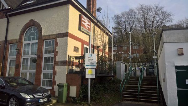
Chipstead station
| Postcode | CR5 3TD |
|---|
Transport
| Travel zone | 6 |
|---|---|
| Tube/Rail lines | |
| Next stations | |
| Nearby stations | |
| Bus stops |
Pine Walk (SE)
Outwood Lane (NE)
Outwood Lane (SW)
|
| Station code (TLC) | CHP |
| Station code (NLC) | 5353 |
| Owner | Govia Thameslink Railway (Southern) |
| National Rail Enquiries | |
Live Departures
Live Arrivals
Usage
Entries and exits
Interchanges
| Year | Entries and exits | Annual change % | Interchanges | Annual change % |
|---|---|---|---|---|
| 2024 | 78,164 | -3.3 % | ||
| 2023 | 80,850 | 39.5 % | ||
| 2022 | 57,976 | 160.1 % | ||
| 2021 | 22,290 | -84.7 % | ||
| 2020 | 145,724 | -5.9 % | ||
| 2019 | 154,918 | -3.8 % | ||
| 2018 | 160,954 | 5.0 % | ||
| 2017 | 153,290 | -14.4 % | ||
| 2016 | 179,110 | 7.7 % | ||
| 2015 | 166,284 | 3.3 % | ||
| 2014 | 160,948 | 3.2 % | ||
| 2013 | 156,026 | 1.8 % | ||
| 2012 | 153,250 | 1.6 % | ||
| 2011 | 150,828 | -2.1 % | ||
| 2010 | 154,002 | -7.1 % | ||
| 2009 | 165,746 | 0.5 % | ||
| 2008 | 164,954 | 12.9 % | ||
| 2007 | 146,109 | 14.2 % | ||
| 2006 | 127,983 | 2.0 % | ||
| 2005 | 125,459 |
Note: Data is for financial years, so 2020 is April 2019 to March 2020
Geography
| Latitude | 51.309276 | |
|---|---|---|
| Longitude | -0.169503 | |
| Easting | 527689 | |
| Northing | 158275 | |
| Grid reference | TQ276582 | |
| UTM reference | 30U 697274 5688023 | |
| what3words | ||
| Plus code | ||
| Distance away |
Postcodes
This map shows the postcodes where this station is the nearest to the postcode (as the crow flies)