Map of Greenwich station, London
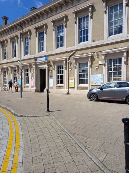
Photo: Sandra C
Greenwich station
| Postcode | SE10 8JQ |
|---|
Transport
| Travel zone | 2,3 |
|---|---|
| Tube/Rail lines | |
| Next stations | |
| Nearby stations | |
| Bus stops |
Greenwich Station (SW)
Greenwich Station (N)
Greenwich Station (S)
Ashburnham Grove (N)
Ashburnham Grove (S)
Greenwich High Road Royal Hill (S)
|
| Station code (TLC) | GNW |
| Station code (NLC) | 5146 |
| Owner | Southeastern |
| National Rail Enquiries | |
Live Departures
Live Arrivals
Usage
Entries and exits
Interchanges
| Year | Entries and exits | Annual change % | Interchanges | Annual change % |
|---|---|---|---|---|
| 2025 | 2,439,476 | 14.0 % | ||
| 2024 | 2,139,956 | -9.6 % | ||
| 2023 | 2,367,020 | 14.9 % | ||
| 2022 | 2,060,808 | 137.7 % | ||
| 2021 | 866,870 | -77.0 % | ||
| 2020 | 3,769,878 | 4.0 % | ||
| 2019 | 3,623,470 | 43.0 % | ||
| 2018 | 2,534,360 | -10.1 % | ||
| 2017 | 2,817,796 | -23.3 % | ||
| 2016 | 3,674,864 | -1.9 % | ||
| 2015 | 3,745,952 | 5.0 % | ||
| 2014 | 3,567,598 | 0.6 % | ||
| 2013 | 3,545,314 | 1.8 % | ||
| 2012 | 3,481,056 | 6.9 % | ||
| 2011 | 3,257,258 | 7.0 % | ||
| 2010 | 3,044,510 | 3.7 % | ||
| 2009 | 2,936,520 | 8.7 % | ||
| 2008 | 2,700,789 | 10.4 % | ||
| 2007 | 2,446,248 | 43.7 % | ||
| 2006 | 1,701,826 | 3.2 % | ||
| 2005 | 1,648,554 |
Note: Data is for financial years, so 2020 is April 2019 to March 2020
Geography
| Latitude | 51.478133 | |
|---|---|---|
| Longitude | -0.01334 | |
| Easting | 537956 | |
| Northing | 177267 | |
| Grid reference | TQ379772 | |
| UTM reference | 30U 707390 5707227 | |
| what3words | ||
| Plus code | ||
| Distance away |
Postcodes
This map shows the postcodes where this station is the nearest to the postcode (as the crow flies)