Map of Orpington station, London
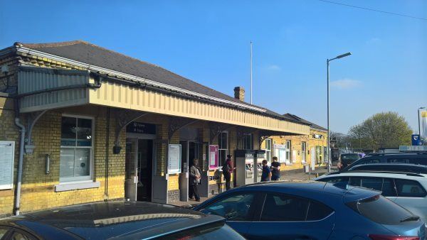
Orpington station
| Postcode | BR6 0SX |
|---|
Transport
| Travel zone | 6 |
|---|---|
| Tube/Rail lines | |
| Next stations | |
| Nearby stations | |
| Bus stops |
Orpington Bus Station (S)
Orpington Bus Station (S)
Orpington (N)
Orpington (SE)
Orpington (W)
Sherlies Avenue (N)
|
| Station code (TLC) | ORP |
| Station code (NLC) | 5122 |
| Owner | Southeastern |
| National Rail Enquiries | |
Live Departures
Live Arrivals
Usage
Entries and exits
Interchanges
| Year | Entries and exits | Annual change % | Interchanges | Annual change % |
|---|---|---|---|---|
| 2025 | 4,989,622 | 8.8 % | 725,083 | 41.8 % |
| 2024 | 4,585,832 | 13.8 % | 511,364 | -11.6 % |
| 2023 | 4,030,402 | 26.4 % | 578,762 | 5.5 % |
| 2022 | 3,189,018 | 143.8 % | 548,635 | 190.9 % |
| 2021 | 1,308,048 | -75.0 % | 188,595 | -86.7 % |
| 2020 | 5,235,814 | -2.1 % | 1,414,436 | 2.0 % |
| 2019 | 5,348,218 | 6.0 % | 1,387,228 | 20.3 % |
| 2018 | 5,044,302 | -2.1 % | 1,153,487 | -0.0 % |
| 2017 | 5,155,016 | 2.2 % | 1,153,874 | -1.3 % |
| 2016 | 5,043,994 | -16.1 % | 1,169,176 | 19.2 % |
| 2015 | 6,014,116 | 7.4 % | 981,193 | 10.2 % |
| 2014 | 5,601,108 | 6.9 % | 890,263 | 1.1 % |
| 2013 | 5,238,978 | 2.6 % | 880,630 | -1.0 % |
| 2012 | 5,105,144 | 0.7 % | 889,356 | -28.7 % |
| 2011 | 5,069,038 | 4.1 % | 1,246,699 | -3.5 % |
| 2010 | 4,867,836 | -2.1 % | 1,292,215 | 164.9 % |
| 2009 | 4,970,528 | -6.5 % | 487,781 | 9.5 % |
| 2008 | 5,313,587 | 4.6 % | 445,471 | 29.3 % |
| 2007 | 5,079,932 | 36.7 % | 344,458 | 19.2 % |
| 2006 | 3,716,456 | 1.7 % | 289,005 | 6.2 % |
| 2005 | 3,654,654 | 272,193 |
Note: Data is for financial years, so 2020 is April 2019 to March 2020
Geography
| Latitude | 51.373294 | |
|---|---|---|
| Longitude | 0.08909 | |
| Easting | 545500 | |
| Northing | 165900 | |
| Grid reference | TQ455659 | |
| UTM reference | 31U 297405 5695360 | |
| what3words | ||
| Plus code | ||
| Distance away |
Postcodes
This map shows the postcodes where this station is the nearest to the postcode (as the crow flies)