Map of Brookwood station
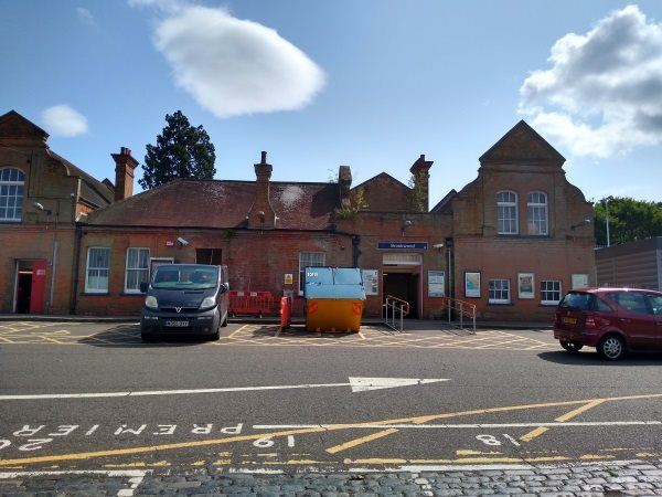
Brookwood station
| Postcode | GU24 0ER |
|---|
Transport
| Nearby stations | |
|---|---|
| Bus stops |
Brookwood Railway Station (E)
Brookwood Railway Station (W)
Brookwood School (W)
Brookwood School (E)
Church Close (E)
Church Close (W)
|
| Station code (TLC) | BKO |
| Station code (NLC) | 5687 |
| Owner | South Western Railway |
| National Rail Enquiries | |
Live Departures
Live Arrivals
Usage
Entries and exits
Interchanges
| Year | Entries and exits | Annual change % | Interchanges | Annual change % |
|---|---|---|---|---|
| 2025 | 874,760 | 11.5 % | 54,611 | 16.2 % |
| 2024 | 784,458 | 8.4 % | 47,009 | 3.4 % |
| 2023 | 723,386 | 31.1 % | 45,458 | 29.1 % |
| 2022 | 551,946 | 169.3 % | 35,208 | 136.9 % |
| 2021 | 204,918 | -78.7 % | 14,860 | -66.3 % |
| 2020 | 963,736 | -6.9 % | 44,070 | -14.2 % |
| 2019 | 1,035,048 | 1.8 % | 51,380 | -1.6 % |
| 2018 | 1,016,392 | 5.1 % | 52,215 | -6.3 % |
| 2017 | 967,406 | -2.8 % | 55,754 | -8.9 % |
| 2016 | 995,142 | 0.5 % | 61,231 | 10.1 % |
| 2015 | 989,826 | 2.4 % | 55,601 | 6.5 % |
| 2014 | 966,250 | 2.7 % | 52,223 | -8.2 % |
| 2013 | 940,704 | 0.6 % | 56,896 | -5.2 % |
| 2012 | 934,706 | 2.5 % | 60,015 | 11.7 % |
| 2011 | 912,268 | 2.3 % | 53,725 | 9.1 % |
| 2010 | 891,976 | -0.5 % | 49,232 | -7.1 % |
| 2009 | 896,710 | 0.9 % | 52,967 | 17.0 % |
| 2008 | 888,411 | 17.4 % | 45,277 | -8.1 % |
| 2007 | 757,006 | 9.0 % | 49,280 | 43.6 % |
| 2006 | 694,226 | 2.1 % | 34,311 | 11.0 % |
| 2005 | 679,893 | 30,901 |
Note: Data is for financial years, so 2020 is April 2019 to March 2020
Geography
| Latitude | 51.303757 | |
|---|---|---|
| Longitude | -0.635748 | |
| Easting | 495200 | |
| Northing | 156954 | |
| Grid reference | SU951569 | |
| UTM reference | 30U 664802 5686259 | |
| what3words | ||
| Plus code | ||
| Distance away |
Postcodes
This map shows the postcodes where this station is the nearest to the postcode (as the crow flies)