Map of Cambridge station
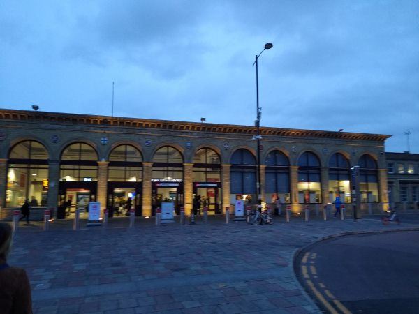
Cambridge station
| Postcode | CB1 2JW |
|---|
Transport
| Nearby stations | |
|---|---|
| Bus stops |
The Busway Railway Station (N)
The Busway Railway Station (S)
Railway Station (N)
Railway Station (S)
Railway Station (N)
Railway Station (S)
|
| Station code (TLC) | CBG |
| Station code (NLC) | 7022 |
| Owner | Greater Anglia |
| National Rail Enquiries | |
Live Departures
Live Arrivals
Usage
Entries and exits
Interchanges
| Year | Entries and exits | Annual change % | Interchanges | Annual change % |
|---|---|---|---|---|
| 2025 | 10,597,572 | 5.6 % | 579,281 | -18.7 % |
| 2024 | 10,033,088 | 7.4 % | 712,233 | 48.0 % |
| 2023 | 9,341,600 | 34.4 % | 481,342 | 23.8 % |
| 2022 | 6,952,780 | 202.2 % | 388,867 | 216.4 % |
| 2021 | 2,300,528 | -80.2 % | 122,908 | -80.4 % |
| 2020 | 11,599,814 | -3.2 % | 626,648 | 12.8 % |
| 2019 | 11,983,320 | 3.9 % | 555,666 | 0.8 % |
| 2018 | 11,530,238 | 0.9 % | 551,305 | 1.9 % |
| 2017 | 11,424,902 | 4.3 % | 541,286 | 8.8 % |
| 2016 | 10,954,212 | 5.1 % | 497,403 | -10.8 % |
| 2015 | 10,420,178 | 6.1 % | 557,532 | 10.8 % |
| 2014 | 9,824,859 | 7.2 % | 503,350 | -4.7 % |
| 2013 | 9,168,938 | 3.9 % | 528,075 | -27.6 % |
| 2012 | 8,823,274 | 7.0 % | 729,555 | -3.9 % |
| 2011 | 8,245,416 | 7.6 % | 758,860 | 46.5 % |
| 2010 | 7,661,146 | 1.2 % | 518,012 | 57.1 % |
| 2009 | 7,571,838 | 8.2 % | 329,669 | 21.3 % |
| 2008 | 6,997,887 | 7.3 % | 271,880 | -14.6 % |
| 2007 | 6,522,309 | 6.3 % | 318,332 | 10.5 % |
| 2006 | 6,137,423 | 1.3 % | 287,957 | 47.2 % |
| 2005 | 6,060,475 | 195,583 |
Note: Data is for financial years, so 2020 is April 2019 to March 2020
Geography
| Latitude | 52.194065 | |
|---|---|---|
| Longitude | 0.137456 | |
| Easting | 546195 | |
| Northing | 257245 | |
| Grid reference | TL461572 | |
| UTM reference | 31U 304355 5786485 | |
| what3words | ||
| Plus code | ||
| Distance away |
Postcodes
This map shows the postcodes where this station is the nearest to the postcode (as the crow flies)