Map of Elephant and Castle station, London
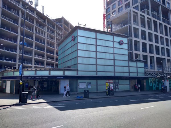
Elephant and Castle station
| Postcode | SE1 6LW |
|---|
Transport
| Travel zone | 1,2 |
|---|---|
| Tube/Rail lines | |
| Next stations | |
| Nearby stations | |
| Bus stops |
Elephant & Castle New Kent Rd (W)
Elephant & Castle New Kent Rd (E)
Hampton Street (S)
Heygate Street (N)
Hampton Street (N)
Elephant & Castle Station (S)
|
| Station code (TLC) | EPH |
| Station code (NLC) | 5246 |
| Owner | Govia Thameslink Railway (Thameslink) |
| National Rail Enquiries | |
Live Departures
Live Arrivals
Usage
Entries and exits
Interchanges
| Year | Entries and exits | Annual change % | Interchanges | Annual change % |
|---|---|---|---|---|
| 2024 | 1,879,984 | 11.9 % | 352,263 | -19.7 % |
| 2023 | 1,680,664 | 27.7 % | 438,837 | 332.5 % |
| 2022 | 1,316,348 | 97.5 % | 101,469 | 105.0 % |
| 2021 | 666,572 | -76.8 % | 49,497 | -81.9 % |
| 2020 | 2,877,610 | -1.4 % | 273,701 | -51.9 % |
| 2019 | 2,919,878 | -8.0 % | 568,835 | 75.8 % |
| 2018 | 3,172,202 | 5.9 % | 323,484 | 9.4 % |
| 2017 | 2,996,564 | -8.8 % | 295,751 | -1.0 % |
| 2016 | 3,287,032 | 0.9 % | 298,867 | 154.1 % |
| 2015 | 3,256,608 | 10.3 % | 117,616 | -22.2 % |
| 2014 | 2,952,812 | 9.3 % | 151,173 | 309.4 % |
| 2013 | 2,701,582 | 5.2 % | 36,925 | 55.1 % |
| 2012 | 2,567,262 | -3.1 % | 23,801 | 1.0 % |
| 2011 | 2,648,421 | -14.9 % | 23,573 | 3.3 % |
| 2010 | 3,111,323 | -6.3 % | 22,815 | 8.5 % |
| 2009 | 3,319,966 | -9.5 % | 21,034 | -89.6 % |
| 2008 | 3,666,983 | 43.6 % | 202,396 | 10.0 % |
| 2007 | 2,553,684 | 24.2 % | 184,043 | 51.4 % |
| 2006 | 2,056,783 | 2.5 % | 121,576 | 5.4 % |
| 2005 | 2,005,980 | 115,397 |
Note: Data is for financial years, so 2020 is April 2019 to March 2020
Geography
| Latitude | 51.494027 | |
|---|---|---|
| Longitude | -0.098726 | |
| Easting | 531940 | |
| Northing | 179144 | |
| Grid reference | TQ319791 | |
| UTM reference | 30U 701392 5708756 | |
| what3words | ||
| Plus code | ||
| Distance away |
Postcodes
This map shows the postcodes where this station is the nearest to the postcode (as the crow flies)