Map of Portsmouth and Southsea station
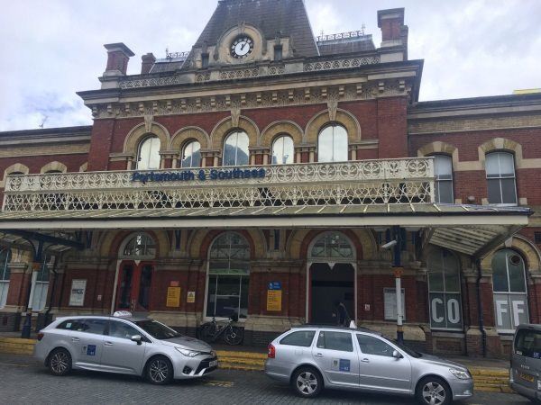
Photo: Martin W
Portsmouth and Southsea station
| Postcode | PO1 1EQ |
|---|
Transport
| Nearby stations | |
|---|---|
| Bus stops |
Civic Offices (NW)
City Shops South (N)
Station Street (W)
City Shops South (N)
Civic Offices (SE)
Station Street (E)
|
| Station code (TLC) | PMS |
| Station code (NLC) | 5537 |
| Owner | South Western Railway |
| National Rail Enquiries | |
Live Departures
Live Arrivals
Usage
Entries and exits
Interchanges
| Year | Entries and exits | Annual change % | Interchanges | Annual change % |
|---|---|---|---|---|
| 2025 | 1,585,586 | -8.6 % | 26,477 | 8.8 % |
| 2024 | 1,735,670 | 1.7 % | 24,344 | 15.1 % |
| 2023 | 1,707,210 | 20.1 % | 21,158 | 32.0 % |
| 2022 | 1,421,952 | 169.5 % | 16,031 | 147.4 % |
| 2021 | 527,564 | -73.5 % | 6,479 | -75.1 % |
| 2020 | 1,990,044 | -3.1 % | 25,972 | 0.6 % |
| 2019 | 2,053,186 | 3.2 % | 25,817 | 7.6 % |
| 2018 | 1,989,572 | -1.1 % | 23,985 | 0.1 % |
| 2017 | 2,012,283 | -4.8 % | 23,951 | -7.2 % |
| 2016 | 2,113,681 | -2.0 % | 25,797 | -12.2 % |
| 2015 | 2,156,486 | 6.1 % | 29,387 | 20.5 % |
| 2014 | 2,032,386 | 3.4 % | 24,390 | -1.7 % |
| 2013 | 1,965,324 | -18.6 % | 24,822 | -1.1 % |
| 2012 | 2,413,088 | 1.2 % | 25,098 | 10.5 % |
| 2011 | 2,383,739 | 4.5 % | 22,711 | -6.5 % |
| 2010 | 2,280,908 | -0.0 % | 24,297 | -6.3 % |
| 2009 | 2,281,128 | 19.8 % | 25,917 | -11.3 % |
| 2008 | 1,904,674 | -5.6 % | 29,227 | 61.8 % |
| 2007 | 2,018,017 | -41.0 % | 18,063 | 99.2 % |
| 2006 | 3,419,093 | 12.0 % | 9,070 | -4.3 % |
| 2005 | 3,052,497 | 9,476 |
Note: Data is for financial years, so 2020 is April 2019 to March 2020
Geography
| Latitude | 50.798495 | |
|---|---|---|
| Longitude | -1.090911 | |
| Easting | 464164 | |
| Northing | 100275 | |
| Grid reference | SU641002 | |
| UTM reference | 30U 634534 5629154 | |
| what3words | ||
| Plus code | ||
| Distance away |
Postcodes
This map shows the postcodes where this station is the nearest to the postcode (as the crow flies)