Map of Liverpool Street station, London
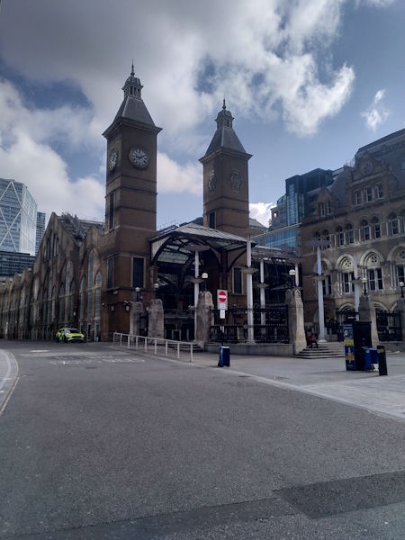
Liverpool Street station
| Postcode | EC2M 7PR |
|---|
Transport
| Travel zone | 1 |
|---|---|
| Tube/Rail lines | |
| Next stations | |
| Nearby stations | |
| Bus stops |
Liverpool Street Station (N)
Wormwood Street (E)
Wormwood Street (W)
Bishopsgate (NW)
Wormwood Street (N)
Wormwood Street (S)
|
| Station code (TLC) | LST |
| Station code (NLC) | 6965 |
| Owner | Network Rail |
| National Rail Enquiries | |
Live Departures
Live Arrivals
Usage
Entries and exits
Interchanges
| Year | Entries and exits | Annual change % | Interchanges | Annual change % |
|---|---|---|---|---|
| 2024 | 94,499,824 | 17.5 % | -100.0 % | |
| 2023 | 80,448,194 | 16.6 % | 5,663,454 | 87.8 % |
| 2022 | 32,165,310 | 186.9 % | 3,015,824 | 166.7 % |
| 2021 | 11,212,008 | -17.9 % | 1,130,924 | -74.0 % |
| 2020 | 65,984,786 | -5.0 % | 4,351,290 | 10.3 % |
| 2019 | 69,482,532 | 3.8 % | 3,946,313 | 4.1 % |
| 2018 | 66,966,512 | -0.6 % | 3,789,731 | 38.1 % |
| 2017 | 67,339,218 | 1.2 % | 2,745,129 | 10.7 % |
| 2016 | 66,556,690 | 4.6 % | 2,480,893 | -21.1 % |
| 2015 | 63,631,246 | 1.0 % | 3,143,570 | 7.9 % |
| 2014 | 63,004,002 | 7.8 % | 2,912,383 | 9.2 % |
| 2013 | 58,448,814 | 2.4 % | 2,667,383 | 13.4 % |
| 2012 | 57,106,502 | 2.4 % | 2,353,014 | 10.8 % |
| 2011 | 55,769,423 | 8.1 % | 2,122,967 | 20.6 % |
| 2010 | 51,596,155 | -6.4 % | 1,760,215 | 25.3 % |
| 2009 | 55,103,416 | -4.6 % | 1,404,473 | -6.7 % |
| 2008 | 57,759,809 | 4.5 % | 1,505,945 | -10.8 % |
| 2007 | 55,265,748 | 16.9 % | 1,688,089 | 16.2 % |
| 2006 | 47,271,234 | -6.3 % | 1,452,848 | -1.6 % |
| 2005 | 50,469,209 | 1,476,438 |
Note: Data is for financial years, so 2020 is April 2019 to March 2020
Geography
| Latitude | 51.517989 | |
|---|---|---|
| Longitude | -0.081426 | |
| Easting | 533160 | |
| Northing | 181596 | |
| Grid reference | TQ331815 | |
| UTM reference | 30U 702486 5711468 | |
| what3words | ||
| Plus code | ||
| Distance away |
Postcodes
This map shows the postcodes where this station is the nearest to the postcode (as the crow flies)