Map of Clapham Junction station, London
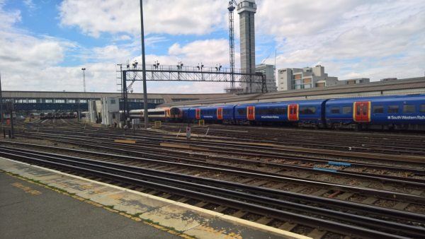
Clapham Junction station
| Postcode | SW11 2QP |
|---|
Transport
| Travel zone | 2 |
|---|---|
| Tube/Rail lines | |
| Next stations | |
| Nearby stations | |
| Bus stops |
Clapham Junction Station (W)
Clapham Junction Grant Road (W)
Clapham Junction Grant Road (E)
Clapham Junction Station Falcon Road (S)
Clapham Junction Station The Falcon (N)
Clapham Junction Station Falcon Road (N)
|
| Station code (TLC) | CLJ |
| Station code (NLC) | 5595 |
| Owner | Network Rail |
| National Rail Enquiries | |
Live Departures
Live Arrivals
Usage
Entries and exits
Interchanges
| Year | Entries and exits | Annual change % | Interchanges | Annual change % |
|---|---|---|---|---|
| 2024 | 22,858,198 | 9.9 % | 20,383,396 | 6.8 % |
| 2023 | 20,790,150 | 19.5 % | 19,090,976 | 29.0 % |
| 2022 | 17,397,120 | 107.8 % | 14,793,662 | 116.8 % |
| 2021 | 8,370,706 | -71.0 % | 6,823,770 | -74.6 % |
| 2020 | 28,892,348 | -2.1 % | 26,902,505 | -8.3 % |
| 2019 | 29,520,132 | 0.3 % | 29,324,019 | -0.9 % |
| 2018 | 29,444,714 | -4.0 % | 29,604,407 | 8.3 % |
| 2017 | 30,680,766 | -5.0 % | 27,330,398 | -10.2 % |
| 2016 | 32,282,220 | 22.0 % | 30,449,390 | 7.1 % |
| 2015 | 26,465,840 | 4.7 % | 28,425,609 | 5.9 % |
| 2014 | 25,287,250 | 7.0 % | 26,846,859 | 15.1 % |
| 2013 | 23,622,718 | 7.8 % | 23,334,118 | 8.0 % |
| 2012 | 21,918,116 | 11.4 % | 21,609,997 | 4.6 % |
| 2011 | 19,671,342 | 10.8 % | 20,667,636 | 0.7 % |
| 2010 | 17,758,808 | 1.8 % | 20,520,598 | 25.5 % |
| 2009 | 17,445,432 | -4.0 % | 16,354,822 | -8.4 % |
| 2008 | 18,180,739 | -3.6 % | 17,863,239 | 38.5 % |
| 2007 | 18,868,026 | 51.8 % | 12,898,160 | 36.4 % |
| 2006 | 12,426,542 | -1.0 % | 9,453,333 | 8.9 % |
| 2005 | 12,550,035 | 8,682,661 |
Note: Data is for financial years, so 2020 is April 2019 to March 2020
Geography
| Latitude | 51.464187 | |
|---|---|---|
| Longitude | -0.170293 | |
| Easting | 527198 | |
| Northing | 175520 | |
| Grid reference | TQ271755 | |
| UTM reference | 30U 696553 5705244 | |
| what3words | ||
| Plus code | ||
| Distance away |
Postcodes
This map shows the postcodes where this station is the nearest to the postcode (as the crow flies)